The Rains of September

Most folks following this blog know of my fascination with meteorology and my expression of said interest by participating in volunteer functions like ‘Skywarn spotting’ and ‘CoCoRaHS’ (Community Collaborative Rain, Hail and Snow network) as well as reporting on the marvelous extremes of weather in The Last Frontier.  I’ve always been a sky watcher and had learned to predict short term weather in the lower 48 just by observing the clouds and winds along with the barometric pressure.  Since relocating to Alaska I’ve had to re-learn this knowledge as it is quite different this far north but I’m having great fun undertaking this re-education.

August is historically Talkeetna’s rainiest month averaging 4.5″ (11.43 cm) of rain but September is a close second at 4.2″ (10.67 cm) of rain.  As you may know from June and July’s wildfires in The Great Land 2015 has been very dry, at least up until this month.  During 2015 only July hit its historical rainfall amount although obviously September is going to grossly exceed its ‘typical’ rainfall!  As I watch the ongoing moderate rains out my office window I am again reminded that in Alaska the weather rules and we humans are just along for the ride and must learn to be both flexible and patient.  Since this latest rain event started last Saturday evening I’ve recorded 2.14″ (5.44 cm) of rain with 1.44″ (3.66 cm) of that amount occurring between 07:00 Sunday morning and 07:00 this (Monday, 09/28) morning.  Since sending in that report to CoCoRaHS this morning I’ve accumulated another 0.33″ (0.84 cm) or so as of 10:40 AKDST and the rain continues:

CoCoRaHS Rain Gauge showing 0.33

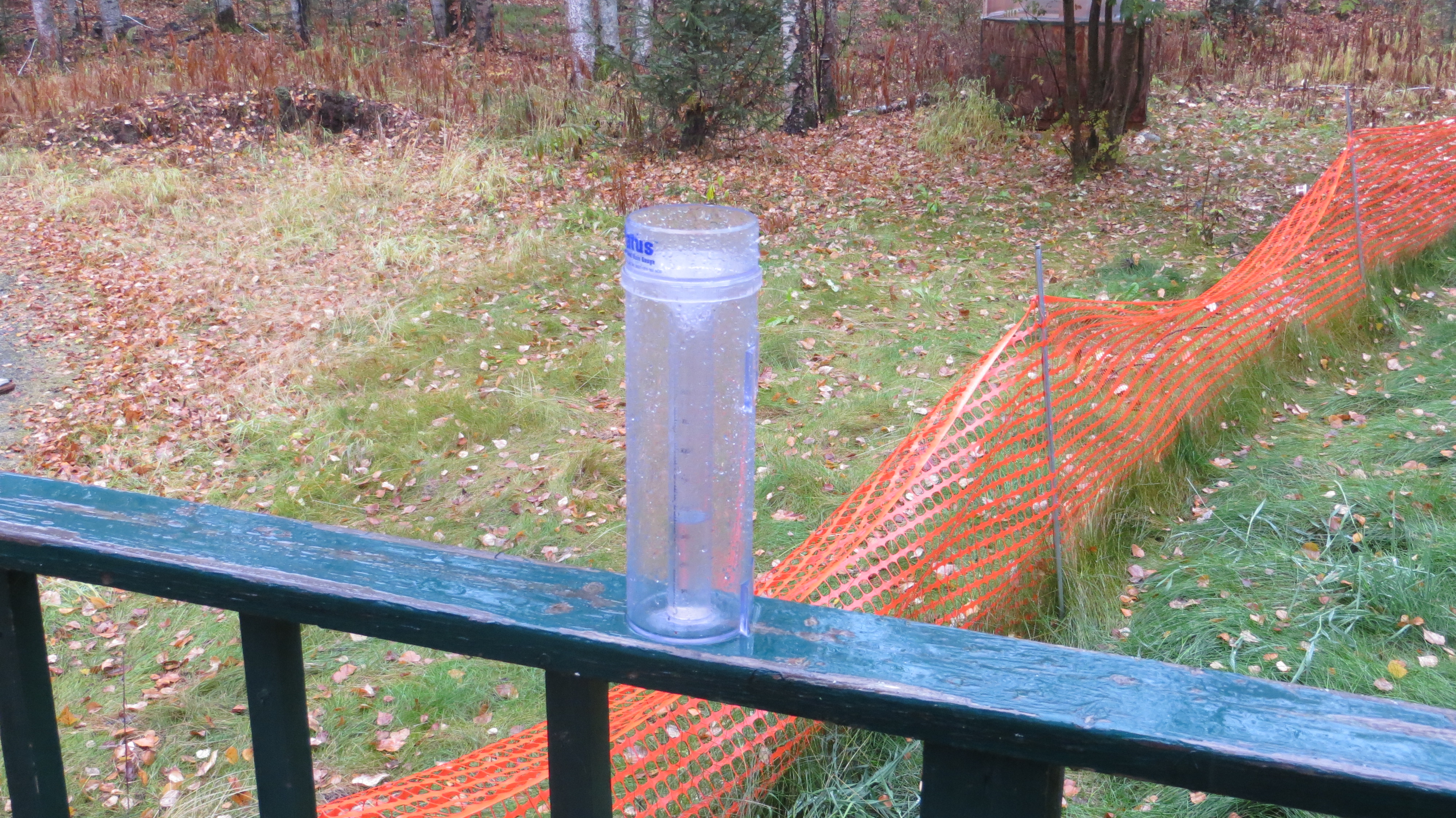
CoCoRaHS Rain Gauge showing 0.33″ accumulated rainfall in previous 3.6 hours!

I believe the aforementioned 1.44″ (3.66 cm) of rain across a 24 hour period is the largest amount I’ve recorded during such a time period since relocating to Alaska in September of 2013.

Yet this rain is just the precursor to what could well be significant accumulating snowfall which NWS is currently projecting to begin in roughly 24 hours for this area.  Everything depends upon the speed at which the very cold mass of Siberian air moves into the Mat-Su Valley; the faster this happens the more snow we will receive.  If it happens sooner than forecast we could see over 6″ (15.24 cm) of snow especially at elevations above 1,000 feet (304.8 m) in the Susitna Valley with larger accumulations further north.  If it arrives later then we’ll see more rain and less snow.  I sympathize with the forecasting folks at NWS because so much affects the movement of such an air mass like pressure, upper level winds, lower level winds in the mountains and temperature.

I am very concerned about the rain; given we’ve already seen 2.14″ (5.44 cm) since the event began Saturday evening and the rain is forecast to continue as moderate to heavy rain into Tuesday we could see amounts above 3.5″ (8.89 cm) across the period.  Because the ground is already beginning to freeze the water cannot soak in as well and hence tends to pool and form torrents which can and do wash out the local road system.  I am expecting to pick up a buddy flying from SW Michigan to Anchorage this Wednesday (09/30) evening and the only driving route to Anchorage is the Parks Highway (AK 3) to the Glenn Highway (AK 1).  There are numerous areas along the Parks between Talkeetna and the intersection with the Glenn which have washed out in the past and these conditions are as extreme in terms of rain as any I’ve experienced in my 24 months living up here.  I have driven the Parks in snow and ice but I’ve never had to negotiate washed out areas; at least that hadn’t been repaired before my arrival.

While I love snow and cold I must admit to hoping that the rains do not continue as they sure appear they will do; I’d rather negotiate a foot (30.48 cm) of snow than try to navigate washed out portions of the Parks!  Ironically my buddy is visiting in part to assist me with mounting an electric winch on my Escape; at least I do have a hand powered ‘come along’ capable of moving 4,000 pounds (1,841.4 kg) in the back cargo area along with my standard winter survival kit.  I never thought I’d be hoping for little snow and no more rain but this is the case!  I will remain glued to the NWS and ADOT websites especially tomorrow morning moving into Wednesday.  It appears Alaska is looking to test me once again and I can only rely on my experience and the reports from the aforementioned services to determine if I should attempt the drive Wednesday evening.  At least my buddy has the option of getting a rental car and motel room should the worst come to fruition…

I've never seen so much ponding water on my driveway! In fact I can never remember seeing any pools of water on the portion in this image!!

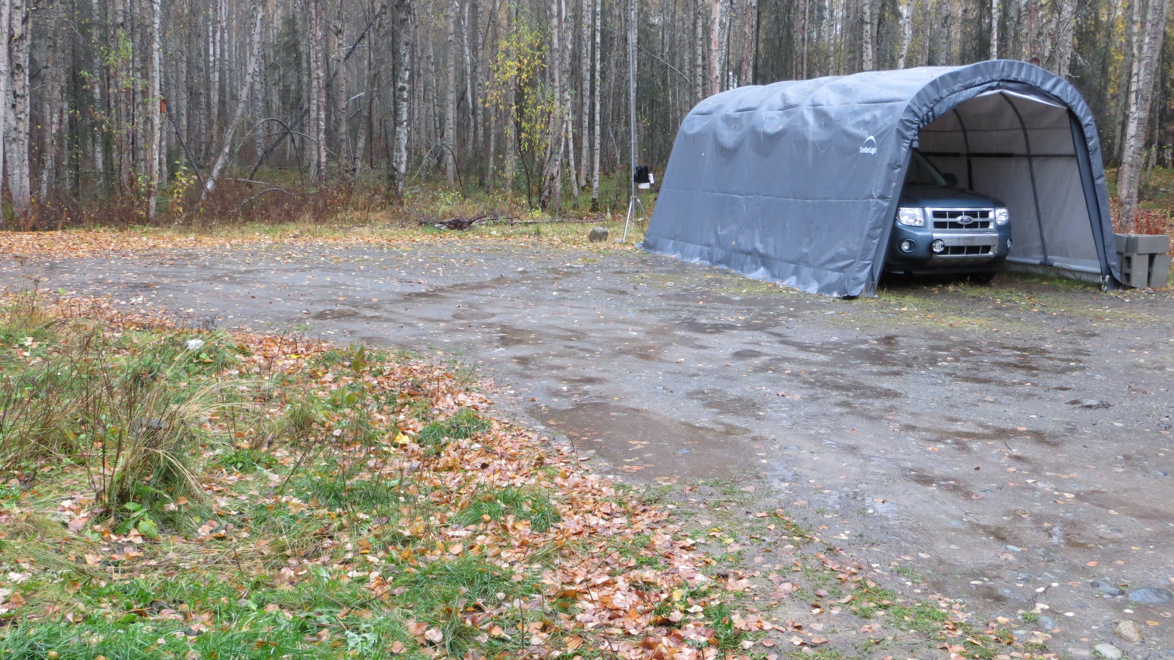
I’ve never seen so much ponding water on my driveway! In fact I can never remember seeing any pools of water on the portion in this image!!


Extreme Alaska!

Anyone reading my previous blogs is aware I am a ‘weather weenie’ in that all things meteorological fascinate me and I love to watch the skies and develop an ability to guess the near term weather based upon current conditions.  Having done this for many decades in the lower 48 I was actually pretty good at it; sure, as I moved to different areas I had to fine tune my ability but overall it’s served me well.  At least until I moved to Alaska; now I can add learning to predict upcoming weather by watching the skies and immediate weather data as yet another area I have much unlearning to do.  I’m okay with this concept because, after all, its dabbling in weather and I love that but it’s also fun to just stretch one’s self.  I have a feeling I’ll be getting both in spades across the upcoming years; yes, it takes years to really develop and refine this ability because so much is based upon experience.

The past eleven days has shown me just how extreme Alaska weather can be in terms of data; interestingly enough, the actual weather has not always reflected the extreme data.  On December 3rd at 03:20 AKST I recorded a barometric pressure of 1,042.872 Mb (30.796″ Hg); this is the highest barometric pressure I’ve ever experienced.  The accompanying weather conditions were classic for extremely high pressure; crystal clear azure skies, no wind and cold temps.  And now, just eleven days later on December 14th, I recorded a barometric pressure of 977.413 Mb (28.863″ Hg) at 00:10 which is the lowest I’ve yet experienced.  In this case what I would’ve expected in terms of weather conditions was completely wrong.  Given such low pressure one would normally expect howling winds and snow falling by the foot because the air temp was around 18 F.  However, while I did record NNE winds to 16 mph on the evening of the 13th by 01:00 AKST on Saturday, December 14th the winds were calm and have remained so.  We did pick up 3.1″ of snow overnight but that doesn’t even merit mention from NWS.  As an aside I noticed that Wayne County in SE Michigan is under a Winter Storm Warning and expected to see a total of 2 to 4 inches of snow; NWS serves all fifty states and uses common terminology in their products like forecasts, advisories and warnings yet said common terminology is obviously ‘tweaked’ by location.  Up here a snow event producing 5″ to 10″ of snow might get a Winter Weather Advisory while the same in SE Michigan would get at least that Winter Storm Warning and probably a Heavy Snow Warning as well.  Regardless, if such low pressure occurred anywhere in the lower 48 one would expect high winds and copious precipitation.

To put these pressure values in some perspective I’ve taken some pertinent information from the http://www.noaa.gov website.  “The accepted world record maximum “sea-level equivalent” pressure for stations below 750 meters was observed at Agata Lake (66 degrees 53 minutes N; 93 degrees 28 minutes E) in Siberia at 1200 GMT on 13 December 1968: that record is 1083.8 mb (32.00 inches) as noted on the site at http://wmo.asu.edu/world-highest-sea-level-air-pressure-below-700m. The station elevation is 263 meters; the temperature was -46 degrees C. Extraordinarily high surface pressures observed nearby at the same time corroborated the record measurement.  Seven stations recorded pressures in excess of 1070 mb, indicating that the pressure at Agata was in keeping with the general situation over the area.”  Here’s what that same site says regarding the minimum barometric pressure:  “The lowest sea-level pressure ever recorded 870 millibars (or 25.69 inches of mercury) in the storm Typhoon Tip. It was recorded 300 miles west of the island of Guam in the Pacific Ocean at latitude 16 deg 44 min north, longitude 137 deg 46 min east, on Oct. 12, 1979.  A hurricane hunter plane flying through the Category 5 storm’s eye of Wilma, on October 19th of 2005 found a minimum central pressure of 882 millibars, this would be an all-time record for an Atlantic storm surpassing the record set in 1988 by Gilbert which was 888 millibars (Mb).  The purist in me demands I point out that water seems to enhance low pressure mainly because said pressures occur in hurricanes (or typhoons).  So what’s the lowest barometric pressure ever recorded over land?  “Here’s the lowest pressure ever recorded over land:  892 Mb (26.35 ” Hg); Craig’s Key, Florida, eye of the Labor Day Hurricane, 2 September 1935.”

Another way of getting perspective on the low pressures is to note that a ‘typical’ Category 2 hurricane would see pressures around 995 Mb while an ‘average’ Category 3 hurricane would see pressures around 960 Mb.  Given this the low pressure we’re now experiencing is in the realm of a Category 2 storm and that’s pretty impressive given its occurring over land and in winter with the cold temps.  I find it amazing that within less than two week’s time I’ve experienced both the highest pressure and the lowest pressure I’ve ever seen.  This really speaks to the extraordinary extremes that seem to be the foundation of Alaskan weather.  And I do love such impressive shifts in the local weather as it really does keep it interesting.  Just another reason I find ‘The Final Frontier’ such an amazing place in which to reside!

Bottomed Out Aneroid Barometer

Bottomed Out Aneroid Barometer; actual pressure was 28.84″ Hg